


|
 |
 |
| |
State of West Virginia Coloring Page Sheets
The 50 States coloring pages
|
|
West Virginia coloring pages are a fun way to teach Pre-K through 3rd grade students history, geography and demographics,
and for elementary students to learn about their own (and other) states.
|
| LIST of States |
|
|

WV - West Virginia Coloring Pages
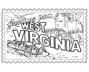
West Virginia Postage Stamp Coloring Page - USPS State Stamp
West Virginia State Quarter Coloring Page - 50 State Quarter
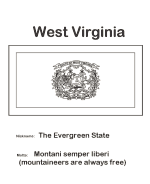
West Virginia State Flag Coloring Page - State Flag to Color
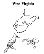
West Virginia Map 1 Coloring Page - State Demographic Map to Color
West Virginia Map 2 Coloring Page - Easy State Shape Outline Map
|
West Virginia is a state in the Appalachian and Mid-Atlantic regions of the United States, bordered by Virginia to the southeast,
Kentucky to the southwest, Ohio to the northwest, and Pennsylvania and Maryland to the northeast. The capital and largest city is Charleston.
West Virginia became a state following the Wheeling Conventions, breaking away from Virginia during the American Civil War. The new
state was admitted to the Union on June 20, 1863, and was a key Civil War border state. West Virginia was the only state to form by
seceding from a Confederate state, and was one of only two states formed during the American Civil War (the other one being Nevada,
which separated from Utah Territory).
West Virginia is located entirely within the Appalachian Mountain range and all areas are mountainous; for this reason it is nicknamed
The Mountain State and also is partially the reason why its motto is "Mountaineers are always free." About 75% of the state is within the
Cumberland Plateau and Allegheny Plateau regions. Though the relief is not high, the plateau region is extremely rugged in most areas.
The average elevation of West Virginia is approximately 1,500 feet above sea level, which is the highest of any US state east
of the Mississippi River.
Please note, we gladly accept submissions from state and local government agencies and departments (Department(s) of tourism, agriculture, etc.)
for display of additional state coloring pages on our site. In addition we accept submissions from established and recognized industries, or local
places of interest (cities, parks, attractions) that may make available quality content that is specific to a particular state. Contact us if
you have the capability and authority to provide such content, we would be happy to promote your state, city, attraction, event, etc.!
*** State information courtesy of Wikipedia ***
|
|
|
|
|
|

|